

The Ha Giang Loop covers roughly 350 kilometers of mountain roads through the far north of Vietnam, passing karst plateaus, minority villages, and river gorges that no other region in the country matches. Most riders do it in 4 to 6 days from Hanoi. This guide covers everything: the route, the stops, the best time to go, what kind of tour to book, and how the experience works for couples, first-time riders, and travelers over 50 who want a private, guided pace rather than a crowded group departure.
What is the Ha Giang Loop?
The Ha Giang Loop is a motorbike circuit through Ha Giang Province in northern Vietnam, roughly 300 kilometers from Hanoi. The route starts and ends in Ha Giang town and passes through Tam Son, Yen Minh, Dong Van, Meo Vac, and back, covering close to 350 kilometers of mountain roads. When starting from Hanoi, the total distance is around 1,000 kilometers across the full trip.
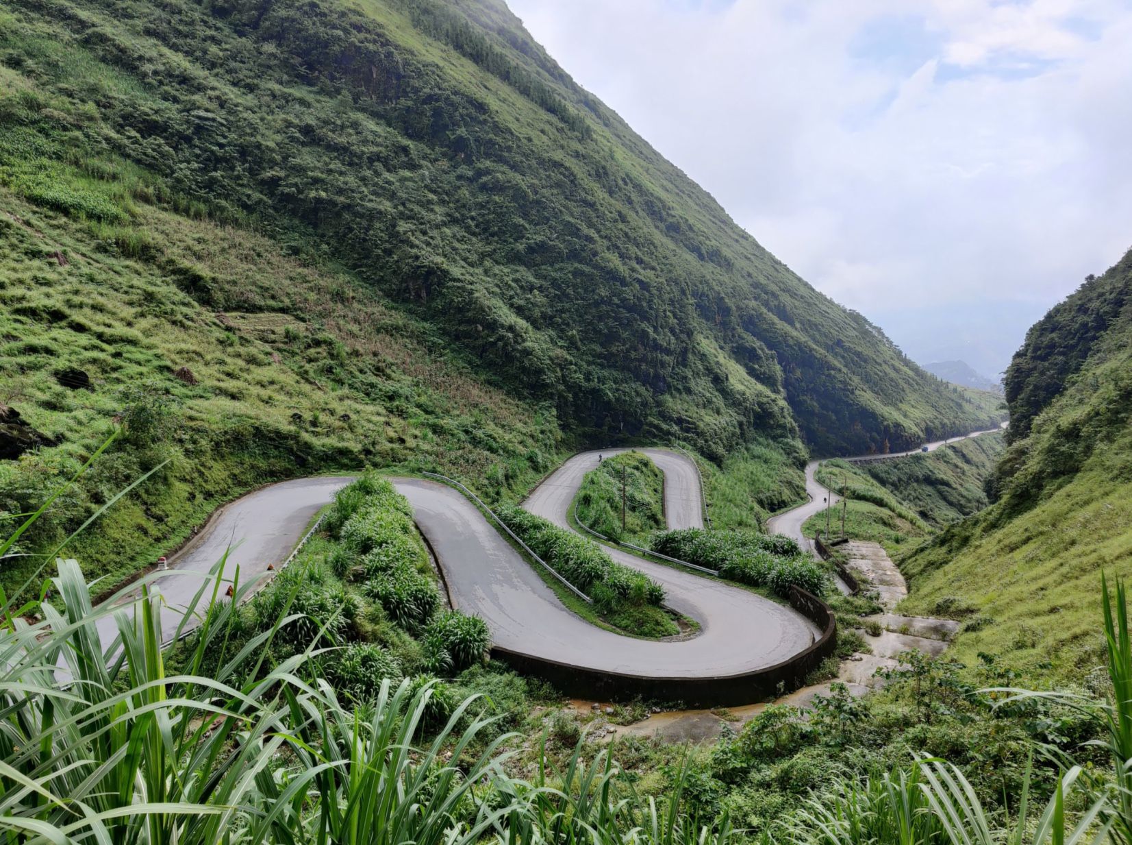
The name “loop” comes from the route’s circular shape: riders leave Ha Giang town, travel northeast along National Highway 4C through the Dong Van Karst Plateau, cross Ma Pi Leng Pass above the Nho Que River, descend through Meo Vac, and return to the starting point. Side routes to Lung Cu, Du Gia, and Ba Be Lake extend the trip to 6 days or more.
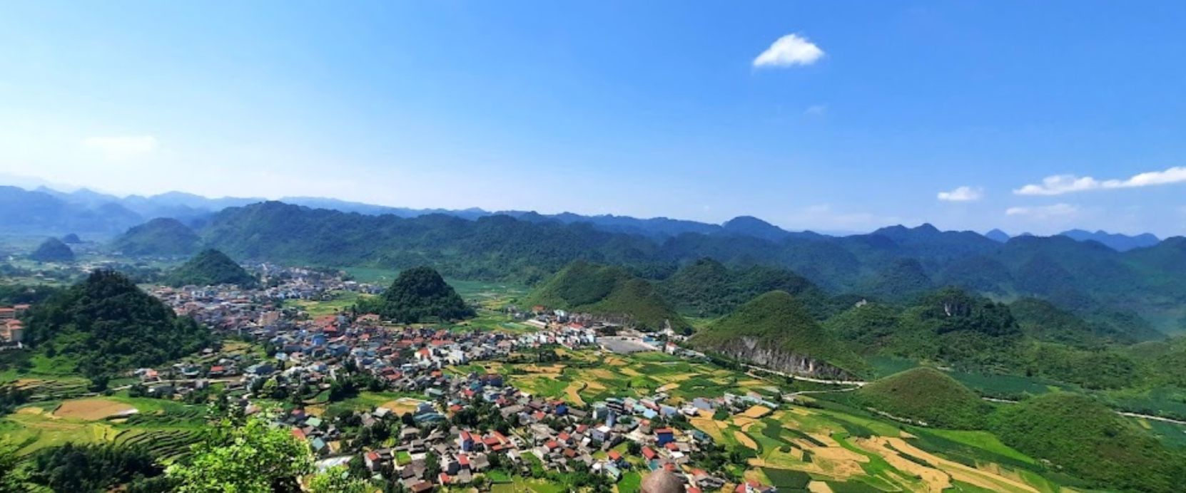
The landscape shifts constantly: terraced rice fields in the valleys, bare limestone karst formations above 1,500 meters, and dense forest on the winding back roads between villages.
- Check out Vietnam motorbike tours
- Book the Ha Giang motorbike tour from Hanoi
Where is Ha Giang on the map?
Ha Giang Province sits in the far north of Vietnam, sharing a border with China’s Yunnan Province. The provincial capital, Ha Giang town, is 320 kilometers from Hanoi, around 6 hours by road. The loop itself starts from Ha Giang town. Most travelers take an overnight bus or a private transfer from Hanoi to Ha Giang town to begin the ride.
How many days do you need for the Ha Giang Loop?
The standard options are 3, 4, 5, or 6 days from Ha Giang town, or 4 to 6 days as a full trip from Hanoi. Four days is the most commonly recommended duration for seeing the main route without feeling rushed. Five or six days allows for side routes, slower riding, and stops that a 3-day trip skips entirely.
Travelers who do 3 days consistently report wishing they had more time. No one who has done 5 days has expressed regret at the length. If you’re deciding between 3 and 5, go for 5.
For riders starting from Hanoi, add a full riding day at each end. A 4-day loop from Ha Giang town becomes a 6-day trip from Hanoi.
The core route covers: Hà Giang → Tam Sơn → Yên Minh → Lũng Cú → Đồng Văn → Mèo Vạc → Hà Giang.
Private Ha Giang Loop tour vs group tour: what’s the difference?
Most tours operating out of Ha Giang town run on 110cc Honda Wave bikes, depart in groups of 20 to 100 riders, follow a fixed schedule, and stay in whatever homestay is available that night. The pace is set by the group, the route rarely deviates, and most stops are the same ones every other tour visits on the same day.
A private Ha Giang Loop tour from Hanoi operates differently. You ride with a dedicated local guide on a 500cc or larger adventure motorbike, the daily distance and stops are decided between you and the guide, the route includes viewpoints and villages that group tours pass without stopping, and accommodation is arranged in advance. That means you’re not sharing a dorm room with strangers at the end of a long riding day.
For couples, travelers over 50, or anyone who doesn’t ride, a private tour also means the option to ride pillion, seated behind your guide, for the entire route. No riding licence required, no gear beyond a helmet. The guide handles the road while you take in the scenery.
Key differences at a glance:
- Group tour: fixed departure, 110cc bikes, shared homestay, 20 to 100 riders per group
- Private tour: flexible start time, 500cc+ bikes, pre-booked accommodation, your group only
- Pillion option: available on private tours, allows non-riders to complete the full loop
Ha Giang Loop for couples and travelers over 50
The Ha Giang Loop is not only for young backpackers on budget bikes. A growing number of couples and travelers in their 50s, 60s, and beyond are doing the loop and consistently rating it among the best travel experiences of their lives. The key is how the tour is structured.
On a private tour, the daily riding distance is adjusted to your comfort level. A typical private day covers 80 to 120 kilometers, with stops built around the best viewpoints rather than a time-pressured group schedule. If a mountain road is rough after rain, the guide knows an alternative. If you want an extra hour at Ma Pi Leng Pass, you stay.
For couples where one person rides and the other doesn’t, the pillion setup works well on a large adventure bike. The passenger seat on a 500cc touring bike is stable, and the guide is an experienced rider who adjusts speed to road conditions.
Accommodation on a private tour is pre-booked. In Dong Van and Meo Vac, there are small lodges with private rooms, hot showers, and comfortable beds. The homestay experience is still available if you want it. It’s simply a choice rather than the only option.
One practical note for travelers over 50: some of the most rewarding viewpoints require short walks of 5 to 15 minutes on uneven terrain. None of the main stops along the route require serious hiking. The boat ride on the Nho Que River at Tu San Canyon is fully accessible and one of the highlights of the entire trip.
Best time to ride the Ha Giang Loop
The two best periods are September to November and March to May. Temperatures average 20 to 26°C during these months, roads are drier, and the rice terraces in September and October are at their most vivid, golden before harvest, then green again as the next cycle begins.
July and August are the rainy season. Roads on the higher passes can be muddy or blocked by landslides, and cloud cover frequently obscures the views from key viewpoints. The loop is still rideable in this period but requires more caution and flexibility.
December to February brings cold and fog to the higher elevations, with temperatures dropping below 10°C at night in Dong Van. Warm layers are essential. Views on clear winter mornings are exceptional, and tourist numbers are lower.
There is no month where the loop is completely unrideable. Conditions simply shift what to expect.
- Check out the best time to visit Vietnam
What to pack for the Ha Giang Loop
Pack light. Everything you need for 4 to 6 days fits in a 20 to 30-liter daypack or in the panniers of an adventure bike. Leave larger luggage at your Hanoi hotel. It’s safe, and every reputable tour operator expects this.
Essentials: a light waterproof jacket, one warm mid-layer (essential November to March), one set of riding trousers or long pants, ankle-covering boots or sturdy shoes, sunglasses, and a dust mask for dry-season roads. A small waist bag for documents, phone, and sunscreen keeps essentials accessible while riding.
Private tours from Hanoi include a windproof jacket and rain poncho. Gloves are worth bringing if you’re riding between November and March. Temperatures above 1,500 meters drop sharply, even during the day.
Keep your passport dry and separate from the rest of your bag. You’ll need it at the checkpoint entering Ha Giang Province, and again if you stay in the Lung Cu area, which requires a local permit.
Ha Giang Loop itinerary: 4 days from Ha Giang town
The itinerary below follows the core loop from Ha Giang town. For riders starting from Hanoi, add Day 0 (Hanoi to Ha Giang, 320km, 6 hours) and a return day at the end.
Day 1: Hanoi to Ha Giang
Depart Hanoi and ride north through the Red River valley, passing rice fields and countryside toward Yen Bai. The first significant stop is Vu Linh, home to Dzao tribal communities settled along the reservoir. Continue through Yen The and along the Luc Yen Chay River before heading to Ha Giang town via Viet Quang. Total distance from Hanoi: approximately 320 kilometers. Plan for 6 to 7 hours in the saddle.
Day 2: Ha Giang to Dong Van via Yen Minh
This day opens on National Highway 4C, one of the most scenic roads in northern Vietnam. The first notable stop is Quan Ba Heaven Gate, a viewpoint overlooking the Twin Mountains (Co Tien) rising from a wide valley of rice fields. The gate sits at around 1,500 meters elevation and is worth 20 to 30 minutes.
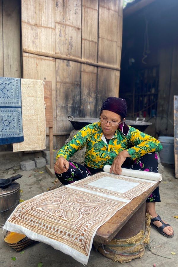
From Quan Ba, the road continues to Lung Tam village, where the H’Mong Lung Tam Linen Cooperative produces handwoven textiles from locally grown flax. It’s a small shop run by local women, selling wallets, bags, and table cloths at fair prices. Worth a stop.
The ride from Tam Son to Yen Minh covers 55 kilometers of increasingly dramatic karst landscape. Just before Yen Minh town, the Đài Quan Sát Yên Minh viewpoint offers a 360° view of the surrounding valleys from a hilltop observation point, with no entrance fee and, on most days, no crowds. Park the bike and walk 10 minutes to the top.
Yen Minh is a small market town and the first overnight stop on the loop. Most restaurants close by 7 PM. Order dinner at your homestay on arrival. The local market opens early and sells fresh produce, mountain herbs, and meat from surrounding villages.
Continuing from Yen Minh toward Dong Van, the road climbs through the Dốc Thẩm Mã viewpoint, also called Chín Khoanh ramp, a series of sharp switchbacks that look spectacular from above. Pull over at the upper viewpoint before descending. Local children sell wildflowers at the top.
Before reaching Dong Van, the route passes along the Vietnam–China border. The valley below marks the boundary between the two countries, with small backroads, rice terraces, and a river running between them. At Lung Cu, a short detour leads to the Lung Cu Flagpole at the northernmost point of Vietnam. The tower is climbable and offers views in all directions. Staying overnight in the Lung Cu and Lo Lo Chai area requires a local permit, which your homestay can arrange on arrival for approximately 200,000 VND (around USD 8).

Day 3: Dong Van, Ma Pi Leng Pass, and Meo Vac
Dong Van is the main hub of the northern loop and an overnight stop for almost everyone riding the route. The Dong Van old town has a handful of cafes, a few small bars, and a local market. Dong Van Karst Plateau Geopark, recognized by UNESCO, covers the surrounding area. The old quarter itself dates to French colonial times and is worth a short walk before departing.
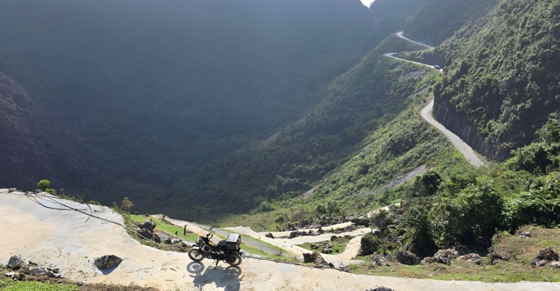
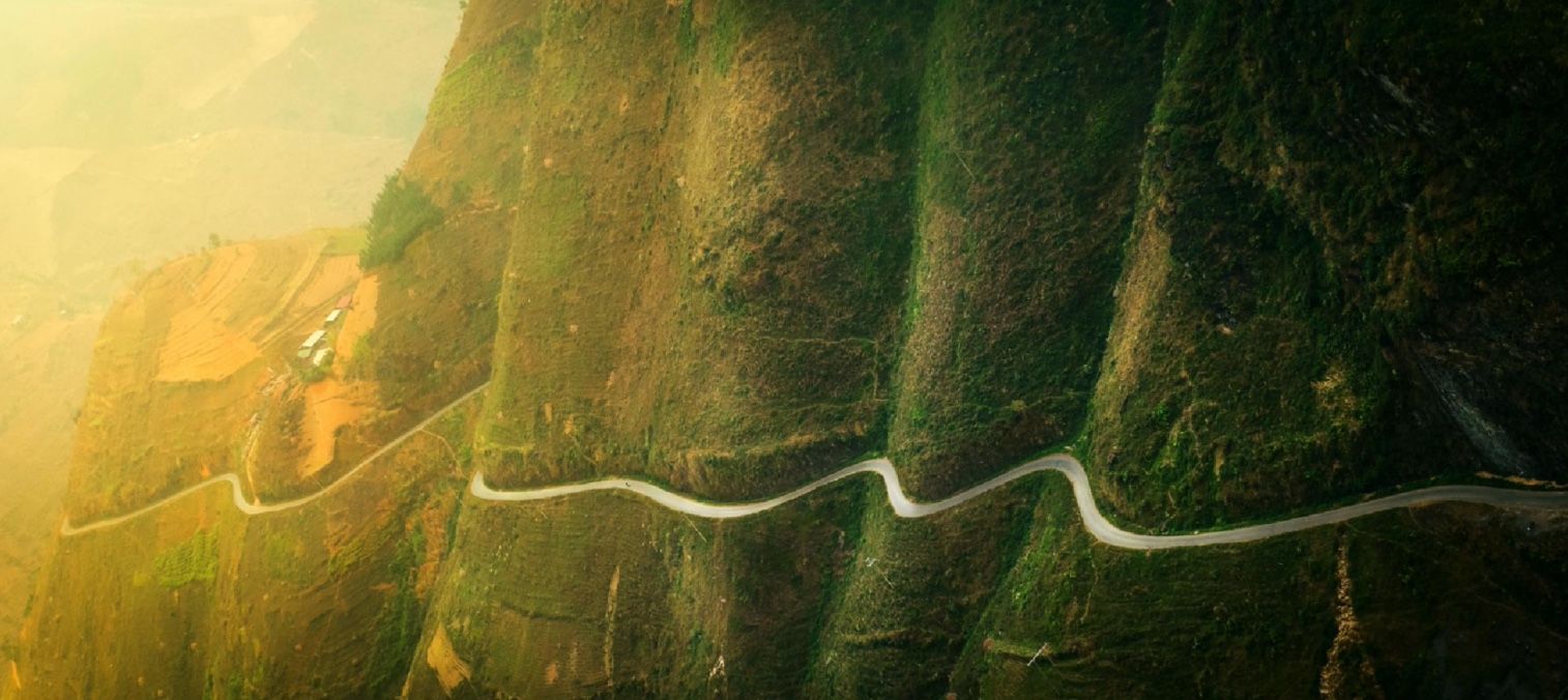
The ride from Dong Van to Meo Vac crosses Ma Pi Leng Pass, the highest and most dramatic section of the entire loop. The pass reaches approximately 1,600 meters, and the road cuts along sheer cliffs above the Nho Que River gorge. At the Tu San Canyon viewpoint, the drop from road to river is roughly 700 meters. Stop here.
After Meo Vac, the boat ride on the Nho Que River through Tu San Canyon (Bến thuyền hẻm Tu Sản) takes 1 to 2 hours and follows the gorge between limestone walls. This section is particularly good for travelers who prefer a rest from the bike, and it’s one of the most visually impressive parts of the entire trip. Book through your guide or at the riverbank on arrival.
Day 4: Meo Vac to Ha Giang via Du Gia
The return route from Meo Vac runs back roads through Bao Lac toward Du Gia village. Du Gia sees fewer tourists than Dong Van, sitting alongside green fields by a riverbank. The village has small homestays run by local farming families and a few trekking trails through the surrounding hills.
The main attraction near Du Gia is Thâm Luông Waterfall (Du Gia Waterfall), a wide cascade with a small cafe selling cold drinks and fresh smoothies at the base. It’s a good place to stop for an hour before continuing to Ha Giang. The pool at the base is swimmable in warmer months.

Between Du Gia and Tam Son, there is a viewpoint that consistently outperforms Ma Pi Leng in traveler photographs. Fewer people know about it, and the valley below is wider and more open. Stop here before the final descent to Ha Giang town.
The Tam Son viewpoint, just before the final approach to Ha Giang city, overlooks stepped karst limestone formations and rice fields in a wide basin. It’s the last significant viewpoint on the loop and worth 15 minutes.
Day 5: Ha Giang to Ba Be Lake (optional extension)
For riders extending to 5 or 6 days, the route continues from Meo Vac through Bao Lac toward Ba Be Lake in Bac Kan Province. The road passes through villages home to Hmong, Dao, Tay, and Nung communities, many of which see few outside visitors. Ba Be is a national park with a large natural lake, limestone caves, and the Dau Dang waterfall. Overnight at a floating homestay on the lake.
Day 6: Ba Be Lake to Hanoi via Halong Bay (full extension)
The 6-day route continues from Ba Be through winding roads to Halong Bay for a day cruise, with seafood, kayaking, and limestone karst formations from the water before a 2 to 3 hour easy ride back to Hanoi. The road to Halong from Ba Be is challenging but passable on a 500cc bike and one of the better riding days of the entire trip.
Key stops along the Ha Giang Loop
The Lung Tam Linen Cooperative
Located in Lung Tam village between Quan Ba and Yen Minh, the cooperative is run by H’Mong women who grow and weave flax using methods passed down across generations. The shop sells bags, wallets, scarves, and table cloths made on-site. Prices are fair and the quality is high. A 15-minute stop here directly supports the village economy.
Đài Quan Sát Yên Minh viewpoint
A free 360° viewpoint just before Yen Minh town. Park at the base, walk 10 minutes up a stone path to the observation platform. The view covers the surrounding valley and karst ridgelines in all directions. Not widely known, rarely crowded, no entrance fee.

Dốc Thẩm Mã viewpoint (Chín Khoanh ramp)
A series of sharp switchbacks on the climb toward Dong Van, photographed from above. The road cuts through nine distinct curves visible from the upper viewpoint. Stop before descending. Local children sell flowers at the top.
Mã Pí Lèng Pass
The most technically demanding section of the loop, Ma Pi Leng Pass crosses at approximately 1,600 meters above sea level between Dong Van and Meo Vac. The road follows the edge of a cliff above the Nho Que River gorge. At Tu San Canyon, the vertical drop from road to river is around 700 meters. Part of the UNESCO-recognized Dong Van Karst Plateau Geopark. Road damage after heavy rain is repaired quickly by local crews, and the pass is almost always passable within 24 to 48 hours of a storm.
Tu San Canyon boat ride
A 1 to 2 hour boat trip along the Nho Que River through Tu San Canyon, below Ma Pi Leng Pass. The gorge walls rise several hundred meters on each side. This is the most accessible highlight on the loop for non-riders and older travelers: no hiking, no steep paths, full views of the most dramatic landscape on the route.
Lung Phin Valley
A wide valley of terraced rice fields between Dong Van and Meo Vac, home to Hmong and Dao communities. The terraces reflect light differently at each season: gold in harvest (October), green in growing season (May to August). One of the better photography stops on the full route.
Don Cao French Fortress
A preserved French colonial military post (Di Tích Đồn Pháp) on the route between Du Gia and Dong Van, listed as a historical site. The fortress offers both a history stop and a viewpoint over the surrounding valleys from the upper ramparts. The walk up takes 15 to 20 minutes on uneven ground and is manageable for most fitness levels.
Du Gia village and Thâm Luông Waterfall
Du Gia is a quieter stop than Dong Van or Yen Minh, set along a riverbank with small family-run homestays and a few walking trails. The Thâm Luông Waterfall, a 10-minute walk from the village, has a swimmable pool at the base and a small cafe. Spend an hour here before continuing to Ha Giang.
Dong Van old town
Dong Van is the main overnight stop in the middle of the loop. The old quarter has French colonial-era buildings, a weekly tribal market, a few bars, and cafes. Trekking to nearby villages and watching farmers work the surrounding fields are the main daytime activities. The town is also the best base for the Lung Cu Flagpole detour.
Yen Minh town
Yen Minh is a small market town and the first overnight stop on the standard loop from Ha Giang. The local market sells fresh mountain produce and meat. Restaurants close by 7 PM, so arrange dinner at your homestay on check-in. The town is functional rather than scenic, but the surrounding roads in both directions are among the most interesting of the whole route.
A note on “happy water”: this is the local term used across Southeast Asia, including Laos, Cambodia, Thailand, and Vietnam, for rice wine or locally brewed spirits made by ethnic minority tribes. You’ll be offered it at homestays. It’s strong. Try it once.
Is the Ha Giang Loop worth it?
The Ha Giang Loop is the most consistently praised multi-day motorbike route in Vietnam and among the best in Southeast Asia. The roads change character every 20 kilometers. The viewpoints at Ma Pi Leng, Dốc Thẩm Mã, and the Du Gia valley approach don’t repeat anything you’ve seen elsewhere. The villages along the route, H’Mong, Dao, Tay, Lo Lo, are living communities, not tourist reconstructions.
The experience has changed over the past five years. Group departures from Ha Giang town have grown significantly in size, and the most famous stops are busier than they were. On a private tour starting from Hanoi, the itinerary sidesteps the busiest departure windows and includes stops that group tours don’t reach.
For couples, the loop works particularly well as a shared experience that doesn’t require both people to ride. For travelers over 50 who ride, the roads require confidence on uneven surfaces but not technical off-road experience. For non-riders, the pillion option covers the entire route. The boat trip through Tu San Canyon and the viewpoints accessible by short walks are fully open to anyone regardless of riding ability.
The short answer: yes, it’s worth it. Worth doing properly.
The honest downsides of the standard group loop
The large group tours operating out of Ha Giang town depart with 20 to 100 riders per group, follow identical routes, stop at the same points at the same times, and stay in basic shared accommodation, sometimes dormitory-style with many travelers per room. Helmets on these tours are frequently below standard. Pillion passengers on 110cc bikes on steep mountain roads is a combination that experienced riders find concerning.
None of this reflects on Ha Giang itself. The landscape, the roads, and the villages are exactly as good as their reputation. The difference is in how you experience them.
Researching your tour before booking, checking the bikes used, the itinerary, the guide’s experience, and the accommodation, is the single most useful thing you can do before committing to the Loop.